Even as El Niño conditions continue to strengthen over the Pacific Ocean, the southwest monsoon is steadily advancing across the country, with the India Meteorological Department (IMD) forecasting fresh progress over large parts of north and central India over the next two weeks.
According to IMD’s extended long-range forecast covering June 26 to July 8, conditions are favourable for the monsoon to advance into more parts of Gujarat, Madhya Pradesh, Chhattisgarh, Jharkhand, Bihar, Uttar Pradesh, Uttarakhand and Himachal Pradesh during the coming week. By early July, the monsoon system is expected to cover the remaining parts of Madhya Pradesh, Uttar Pradesh, Uttarakhand and Himachal Pradesh, while also making further inroads into Punjab, Haryana, Delhi, Rajasthan and parts of Jammu and Kashmir.
El Niño strengthens
The IMD said the atmosphere has now fully responded to warming sea surface temperatures over the equatorial Pacific, with the ocean-atmosphere system now showing clear signs of El Niño conditions. Forecasts suggest the El Niño pattern is likely to strengthen further during the southwest monsoon season.
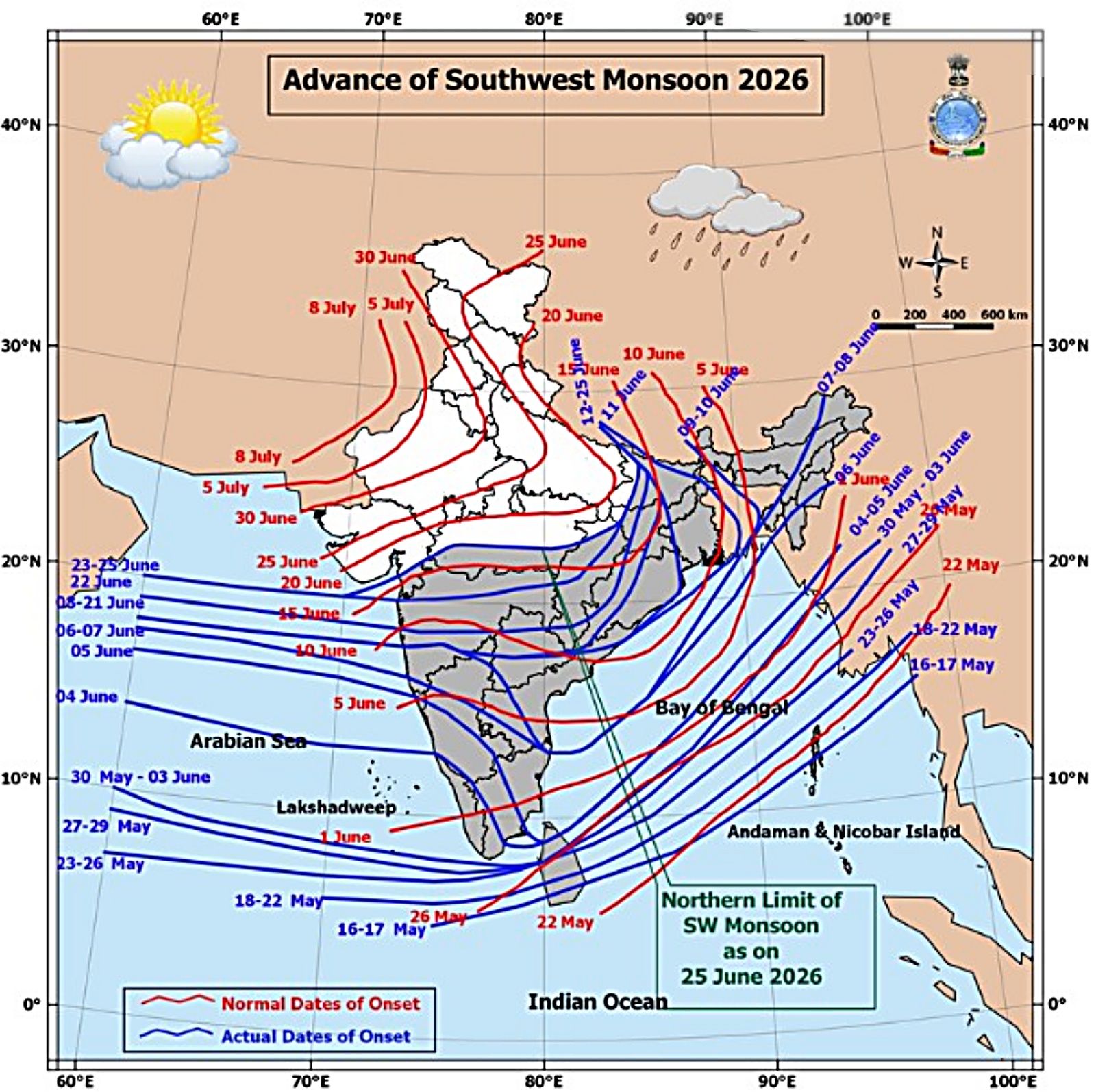 Progress in the Southwest monsoon. (Source: IMD)
However, the Indian Ocean Dipole (IOD) remains neutral and is expected to stay that way throughout the season.
The Madden-Julian Oscillation (MJO), a tropical weather pattern that influences rainfall, is currently in a phase that should help trigger stronger thunderstorms over the north Bay of Bengal, which could support increased rainfall during the first week of the forecast period.
Heavy rain in eastern and northeastern India
During the week ending July 1, light to moderate rainfall is expected over most parts of central, eastern and peninsular India, with isolated heavy to very heavy showers over Sub-Himalayan West Bengal, Sikkim, Bihar and the Northeast.
Thunderstorms accompanied by lightning and gusty winds are also likely over central, eastern, northeastern and northwestern India, besides parts of the west coast and peninsular region. Dust storms may occur over isolated pockets of the northwest plains.
Story continues below this ad
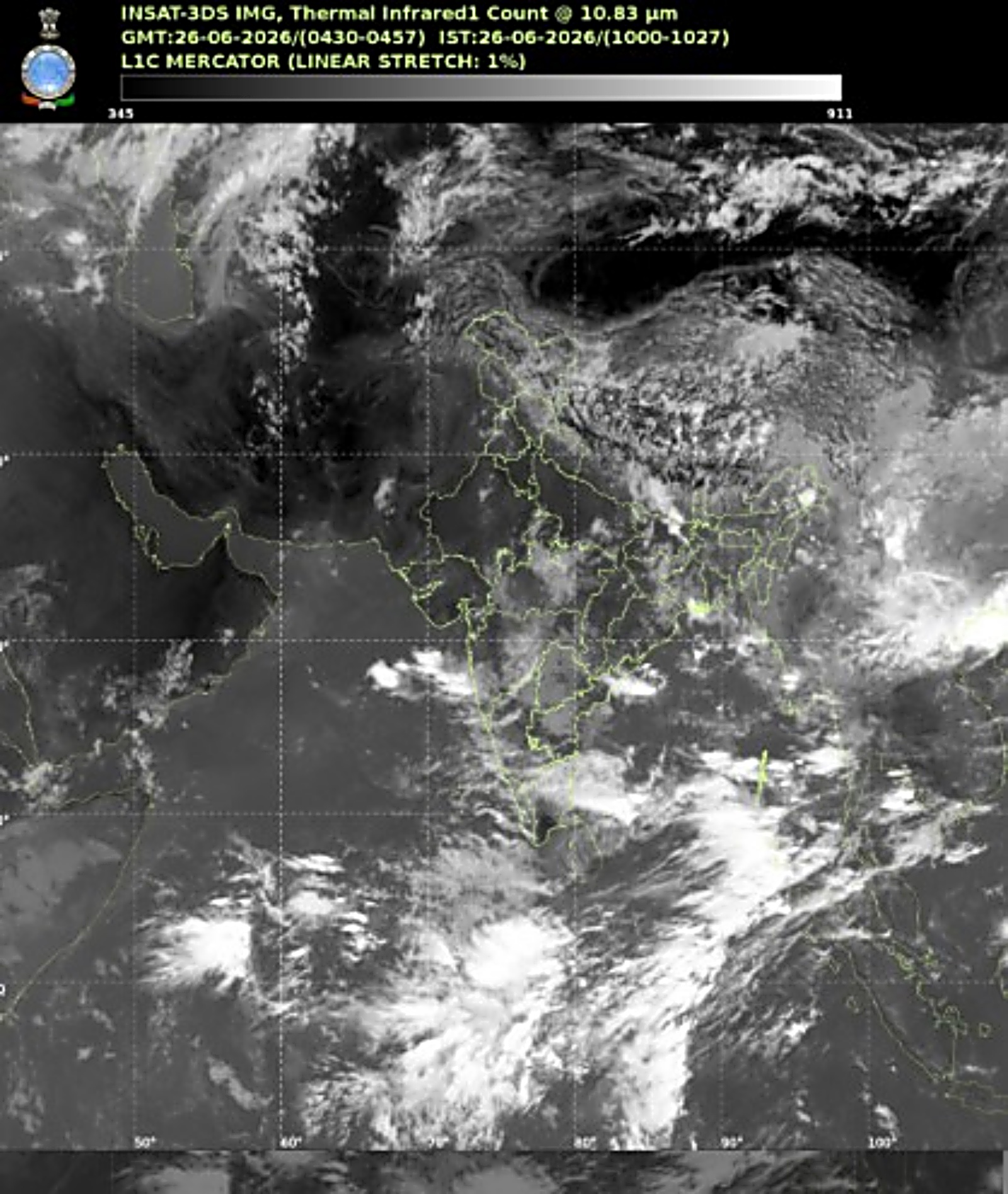 Satellite image. (Source: IMD)
While rainfall is expected to remain below normal over several parts of the country during the first week, southern peninsular India and the Northeast are likely to receive normal to above-normal rainfall.
From July 2 to July 8, rain is expected to become more widespread as the low-level Somali Jet strengthens and favourable monsoon systems develop over the Bay of Bengal. Western disturbances may also bring rain to the western Himalayan region.
‘Red’ alert for North Bengal
North Bengal is set to bear the brunt of the upcoming wet spell, with IMD issuing ‘red’ alerts for several districts.
Jalpaiguri will remain under an ‘orange’ alert on June 26 and 27, when thunderstorms, lightning, gusty winds of 30-40 kmph and heavy to very heavy rainfall are expected. The district has been upgraded to a ‘red’ alert from June 28 to June 30, with forecasts of extremely heavy rainfall exceeding 20 cm at isolated places.
Story continues below this ad
Darjeeling, Kalimpong, Alipurduar and Cooch Behar have also been placed under ‘red’ alert for the same period, with forecasts warning of widespread heavy to very heavy rainfall, thunderstorms and strong winds.
Meanwhile, North Dinajpur, South Dinajpur and Malda remain under ‘orange’ alert for heavy rainfall and thunderstorms.
The weather office has cautioned that intense rainfall could lead to waterlogging, flash floods in low-lying areas and landslides in the Himalayan districts.
Rain and waterlogging in Kolkata
Heavy rain accompanied by thunderstorms and gusty winds battered Kolkata and adjoining districts on Thursday, leaving several roads waterlogged, disrupting traffic and causing widespread inconvenience. Waterlogging was also reported at SSKM Hospital, affecting movement within the premises.
Story continues below this ad
The IMD has forecast thunderstorms with lightning and gusty winds to continue across parts of south Bengal, including North and South 24 Parganas, Purulia, Birbhum, Bankura, Murshidabad and Jhargram, till June 30.
VIDEO | West Bengal: Waterlogging at SSKM hospital as rain lashes several parts of Kolkata.
(Full video available on PTI Videos – https://t.co/n147TvrpG7)#WestBengal pic.twitter.com/TPdoSQ4zxZ
— Press Trust of India (@PTI_News) June 25, 2026
Mumbai rain
Mumbai woke up to heavy rain on Friday. Cloudy skies are likely to persist throughout over the next two days, with rain continuing. IMD has forecast maximum temperatures around 33 degrees celsius and minimum temperatures near 24 degrees Celsius.
VIDEO | Mumbai wake up to a pleasant morning after couple of days of heavy rainfall. Visuals from Marine Drive, Nariman Point. #MumbaiNews #WeatherUpdate
(Full video available on PTI Videos – https://t.co/n147TvrpG7) pic.twitter.com/Eg1n0M1TMg
— Press Trust of India (@PTI_News) June 26, 2026
Some areas of the Maharashtra capital, however, reported waterlogging on June 24 and 25. Heavy rain could worsen flooding in some city pockets.
Maharashtra weather updates
Across Maharashtra, light to moderate rain or thundershowers are expected over most districts of Konkan-Goa, Marathwada and south Madhya Maharashtra, with rain likely to continue until July 1. Temperatures are expected to remain largely stable over the next couple of days before rising slightly.
Delhi weather today
The national capital is expected to witness a partly cloudy sky with chances of light rain, thunderstorms and lightning on Friday. Gusty winds reaching 40-50 kmph, with occasional gusts up to 60 kmph, are likely during the afternoon and evening.
The unsettled weather is expected to continue through the weekend and into next week, with intermittent light rain and strong surface winds. Daytime temperatures are forecast to hover between 39 degrees celsius and 41 degrees celsius, while minimum temperatures are expected to remain around 26 degrees celsius to 28 degrees celsius.
Story continues below this ad
Heavy rain on the West Coast
The IMD has also forecast rainfall over Konkan & Goa, coastal Gujarat, Kerala and Coastal Karnataka, with isolated heavy to very heavy rainfall during the coming week. Heavy showers are also likely over parts of Madhya Maharashtra and south interior Karnataka towards the end of June.
In the Northeast, Arunachal Pradesh, Assam and Meghalaya are expected to receive repeated spells of heavy to very heavy rain through the week.
Heatwave this week
Heatwave conditions are likely to persist briefly over isolated parts of Bihar, Jharkhand and eastern Uttar Pradesh, with severe heatwave conditions possible in some areas until June 27.